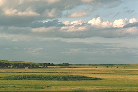
Unique in its landscape features as appreciated by people representing generations, the Great American Sandhills have many special spaces with scenic views and distinctive perspectives many residents want to save and preserve for now and future generations. The sand dunes domain has places such as these shown here without cellular towers, industrial powerlines that traverse so many miles of country land, and especially where there is not a single wind turbine visible anywhere while enjoying some time atop a hill, perhaps enjoying a great view of the local landscape.
Known places of these sorts are much fewer every year, because some businesses and people are completely focused on towers and changes which they convey as delusional improvements. The results are deplorable.
This land of various sorts of dune with some many sorts of grass and plants, is the last vestige of an expansive natural landscape in the western hemisphere. These pictures convey a singular perspective. Some of the shown places were images taken with one camera of another during past years, during my project to drive atop each of the known tallest sand dunes in the region, as previously reported.
Each and every one of these images are copyright (c) 2016 James E. Ducey. They may not be reused or reposted in any manner elsewhere, either via print, electronic or any other sort of media, without express written permission.
Dora Lake meadow after a seasonal storm, 1993
Wild Horse Hill, Grant county looking southeast; 6 Sep 1993
OO Reserve, Grant county, view to the south after a rainstorm; 6 Sep 1993
Irwin area meadow ranch; summer 1995
Eldred Ranch cattle and marsh as observed from Vic's sky horse; 27 Sep 1995
Baldy Hill, view to the west; 18 May 1995
Carson Lake perspective; 02 Jun 1995; just to the south of this distinctive lake - especially notable for its birdlife - the R-Project industrial powerline is planned for construction by the Nebraska Public Power District, with the desecration to be initiated in 2017
Mother Lake cloudscape, Adam Ranch place; 10 Jun 1999
Irwin area meadow ranch; summer 1995
Olson contract crew harvesting hay at Fawn Lake Ranch, Cherry county; 16 Aug 1999
Henderson Dry Box horses, Carrico Lakes, Cherry county; 10 May 2000
Longhorns in Cherry county during drive taking them from Fort Niobrara NWR to Fort Robinson State Park; 13 Nov 2000
Aerial view of the Mother Lake county, Cherry county; 3 May 2002
Old Baldy Hill view, looking westward; 30 May 2001
Wolf Lake perspective, western Cherry county; 27 Jun 2002
Merz Ranch hay meadow, Swan Lake southwest of Brownlee; 16 Jul 2002
Snowy road view, Abbott Unit of the Rex Ranch, western Grant county; 12 Apr 2008
Horses in Wamaduze Valley, view from along Brownlee to Highway 97 road; 16 Jul 2009
East Tennessee Valley, Fawn Lake Ranch; 2 Jun 2010
Farm Flat livestock, central Cherry county; 2 Jun 2010
Defair Lake WMA south of Hyannis; 8 Jun 2010
Steverson Lake WMA, Cherry county; 8 Jun 2010
Goose Creek valley, southeast Cherry county; 10 Jun 2010
Goose Creek valley hay meadow, southeast Cherry county; 25 Sep 2011
Sibbitt and Henderson meadow just north of Hyannis; 29 Sep 2011
Vinton Ranch horses with Snyder Valley in the background; 30 Sep 2011
Self-portrait taken atop Indian Hill - looking eastward - right near Old Baldy Hill in southwest Cherry county; 18 October 2001
Each of these places were visited with landowner permission. Many miles were driven and so many pleasurable hours were part of my pictographic and birdly travels. Many thanks to those property owners that were so cordial in allowing access. Otherwise any attempt to capture these unique perspectives would not have been possible. A number of these pictures are part of the Great American Sandhills photographic collection as denoted to the University of Nebraska-Lincoln many years ago.


