Showing posts with label Flood 2011. Show all posts

23 November 2011

Prime Habitat for Plovers Occurred After Missouri River Flood

Partially flooded bottomlands along the Missouri River provided prime habitat for plovers this autumn, following the receding waters of the 2011 flood. Suitable habitat which is not typically present occurred at the Horseshoe Lake Flats (east of Fort Calhoun), the La Platte Bottoms, at Schilling WMA, Hamburg Bend mitigation area, and along southwest of Bartlett, in Iowa.

Few records are available for the September-November period, but observations indicate numbers exceeded any previously known occurrences.

A lesser number were present in late September, but by latter October, the magnitude of their occurrence became apparent, based upon the first report by Clem Klaphake, a birding enthusiast from Bellevue. A first visit of his east of Fort Calhoun was followed by trips to the Schilling WMA east of Plattsmouth and then to a mitigation area south of Nebraska City.

After reading the exciting news online, other birders visited the Horseshoe Lake Flats to see what was present.

The peak count was made on the lowlands near Bartlett, Iowa, as reported in an IABirds post by Keith Dyche. What a number of plover he saw, along with large numbers of other species, especially the huge gathering of the America White Pelican, with enough present that an Omaha newspaper photographer took pictures and the editors thought they were special enough that a reporter wrote a short and relatively insignificant article that provided trite comments of no importance to the "real" birding community.

The count of more than a hundred plover was contributed by Jon King, to the Missouri Birds online forum.

Each detail recorded indicates the occurrence of this species in a distinctive and important manner. The available counts indicate what is known of this plover's occurrence at a few sites. The big unknown is what might have been present at the many other places along the Missouri River bottoms which were not visited. There may have been thousands of these birds appreciating habitat conditions suited to their survival?

The following available records are grouped into particular districts to provide a succinct list.

Date - 2011

Horseshoe Lake District

La Platte District

Plattsmouth District

Nebraska City District

Bartlett District

Squaw Creek District

09/28

- -

45

- -

- -

- -

- -

10/17

- -

- -

- -

- -

- -

1

10/24

- -

- -

- -

- -

- -

14

10/25

300-350

- -

- -

- -

- -

- -

10/26

- -

- -

14

- -

- -

- -

10/27

338

- -

95

- -

- -

- -

10/28

125

3

33

- -

- -

- -

10/29

152

- -

- -

- -

543

- -

11/01

- -

- -

- -

27

- -

102

11/05

27

- -

- -

- -

- -

- -

11/12

- -

- -

- -

- -

- -

4

11/13

7

- -

- -

- -

- -

- -

11/19

- -

- -

- -

- -

- -

1

11/25

- -

- -

- -

- -

4

- -

The Horseshoe Lake Flats observations convey the best numbers as based upon repeated visits. These observations denote the most birds of this species to have been reported for the state. The November 13 date is also one of the latest known.

The first report from near Bartlett was a single view of what was probably a greater occurrence than what is now known. There were four present east of Bartlett on the 25th, with two of them reported as missing a foot, according to Keith Dyche.

A report of the drab colored plover of the season was one noted by Larry Lade, at Squaw Creek NWR. By the time of his visit, refuge staff had ended their shorebird surveys, so any notes on this group of species were dependent on visiting birders.

It was an exciting season to see the American Golden-Plover in the Missouri River Valley. More records might have been gathered, but the efforts of birders, paying for their own gas and on their own time, is always appreciated.

Plover morning at the Horseshoe Lake Flats, November 5, 2011.

Recent Occurrences

Recent reports can be included to indicate the extent of occurrence of large numbers of this species.

On March 25, 2000 about 150 were observed at Forneys Marsh SWA, in western Iowa.

There were 188 at Bigelow Marsh, in northwest Missouri on April 21, 2004.

Squaw Creek NWR had a reported 120 on April 17, 2007, according to a note submitted to the Missouri birds online forum.

There are a number of reports for lesser numbers during the past ten years.

Historic Occurrence

The first record of the American Golden-Plover is from the Engineer Cantonment, from some time during the stay of the Long Expedition from late autumn 1819 to late spring 1820.

There are several records during the 1870s, associated with the myriad of birds taken during club hunts in the spring and autumn. An October 13, 1874 hunt listed 34 birds as being taken by shootists afield in eastern Nebraska, in the vicinity of the river.

On October 21, 1886 a single bird of this species was included in the take from the club hunt at the Stillwater Bottoms, a historic name for the lowland east of Fort Calhoun.

In 1888, they were noted as occurring along the flats near the river east of Peru.

There are only a few subsequent records, mostly for the 1910s, until the 1990s, when sightings still continued to be occasional.

Another Plover Considered

Numerous Black-bellied Plover also took advantage of conditions on the river bottoms this autumn.

Larger numbers were noted at the Horseshoe Lake Flats, along Highway Two in western Iowa near the river and at Squaw Creek NWR, as seen during regular bird surveys done by refuge staff.

There are fewer records readily available in the region for this species than for the American Golden-Plover.

29 October 2011

Birdly Wonders of Saturday Morning Along Eastern Nebraska

The following notations indicate the wonderful variety of species about on the morning of Saturday on 29 October 2011. The outing started at north downtown to quickly check for bird strikes at Qwest, and then onward to the east side of Carter Lake for the 38th bird survey this year. The day provided some appreciated surprises.

The Carter Lake District includes Carter Lake, Levi Carter Park which includes the Levi Carter Pond on its west edge. The number of coots here continues be impressive as it has been since mid-October. Coots abound at the lake these days.

Common Name -- Carter Lake District -- Horseshoe Lake Flats -- Hummel Park by Ponca Creek
Canada Goose -- 15 -- --
Wood Duck -- 15 -- --
American Wigeon -- 3 -- --
Mallard -- 101 -- --
Northern Shoveler -- 14 -- --
Northern Pintail -- 1 -- --
Canvasback -- 1 -- --
Redhead -- 24 -- --
Pied-billed Grebe -- at least 33 -- 8 --
Red-tailed Hawk -- 1 -- 1 --
American Coot -- 5700 -- --
American Golden-Plover -- -- 152 going about their business --
Killdeer -- -- 332 --
Sanderling -- -- 3 splendid in their strikingly white plumage dramatic upon the drab, formerly flooded agland --
Least Sandpiper -- -- 23 --
White-rumped Sandpiper -- -- 1 --
Long-billed Dowitcher -- -- 9 poking away in the muddy substrate --
Wilson's Snipe -- -- 2 --
Ring-billed Gull -- -- 2 --
Mourning Dove -- 2 -- --
Belted Kingfisher -- 1 -- --
Red-bellied Woodpecker -- 1 -- -- 2
Downy Woodpecker -- 1 -- -- 2
Hairy Woodpecker -- -- -- 2
Northern Flicker -- 1 -- -- 1
Blue Jay -- 1 -- -- 2
American Crow -- -- -- 1
Black-capped Chickadee -- 2 -- -- 5
Tufted Titmouse -- -- -- 2
White-breasted Nuthatch -- 1 -- -- 6
Winter Wren -- 1 -- -- 1
Ruby-crowned Kinglet -- -- -- 2
Eastern Bluebird -- -- -- 2
American Robin -- 12 -- -- 3
European Starling -- 23 -- 17 --
Cedar Waxwing -- -- -- 2
Yellow-rumped Warbler -- 2 -- --
Dark-eyed Junco -- 3 -- -- 6
Snow Bunting -- -- 2 --
Northern Cardinal -- 1 -- -- 2
Red-winged Blackbird -- 22 -- --
Eastern Meadowlark -- 3 -- --
Common Grackle -- 2 -- --
House Finch -- 6 -- --
American Goldfinch -- 2 -- -- 2

Fewer than fifty species, but this number really means nothing as it was seeing the different birds and watching their antics while listening to their calls is what was most important and splendid as presented by each bird which got particular attention.

The return of the feathered mites (Winter Wrens) was the highlight of the crisp morning. Noting a Winter Wren at Levi Carter Park is the first record for this species at this locale (providing a record for the 100th species during 2011), based upon records which go back more than 125 years. The wren was first heard, then after time taken to listen closer, was heard again, and finally seen when flushed from the edge of the Levi Carter pond. This sighting also happened despite some nitwit wondering what time it was. Surprisingly seen were meadowlarks, near where some bum had parked their car and seemingly passed out some hours earlier in the drivers seat, which had to be ignored, as well as their morning routine which they though no one noticed.

The Horseshoe Lake Flats continue to convey a post-flood situation following the great flood of 2011. The variety and numbers of species is impressive and something to appreciate, preferably in a relaxed manner, where the birds get an individual focus and attention to details which convey their identity.

It was quite exciting to get exquisite views of the Snow Buntings on a bit of ground among the golden-plovers! This was the first time this species has been personally observed! It was a magnificent sight. One of the two present perched atop a relict bit of cornstalk to present a grand view of the bird and its features in the morning light. A closeup photograph could have been enjoyed for a long time.

These records continue to indicate the importance of ephemeral and conserved habitats in the Missouri River valley on the fringe of east-central Nebraska.

At the end of the outing, a rare event was noted upon the Missouri River. A tugboat was pushing four fully-laden barges up the river, as noted at the cross-river bridge northeast of Florence. This is significant as barge-traffic has been severely inhibited due to the extensive flooding in previous weeks.

Towboat Mary Lynn pushing barges up the Missouri River.
The boat is out of the port of St. Louis.

Dangerous Nature Center

While at Hummel Park, an opportunity was taken to get a close look at the recently completed nature center. Immediately noticed was the danger the glass is presenting to birds within the park. A picture indicates the reflectivity of the windows which convey that they are a part of the forest setting.

City officials had said there would be blinds placed on the windows. Obviously this is not the case! This structure is now a hazard to the many birds present in the park, and during the autumn migration, an especially dangerous time for birds as they make their way southward.

22 October 2011

Post-flood Assessment Underway Along Missouri River

Federal officials are currently evaluating conditions following the extensive flooding at properties they manage along the Missouri River from Ponca State Park to Rulo, Nebraska.

At over 20 sites owned by the Army Corps of Engineers, efforts are now underway to evaluate what has happened after the more than one hundred days of water flows above flood stage in the river valley. This process will continue for the next few months.

Additional sites managed by partners in river habitat management are also being evaluated. Assessment work is being done by the Iowa Department of Natural Resources, Nebraska Game and Parks and at two federal refuges in this section of the river which are maintained by the U.S. Fish and Wildlife Service.

"We are doing visual assessments and using aerial photographs," at Corps' properties, said Jolene Hulsing, a natural resources specialist in the Omaha District of the Army Corps of Engineers. Not all of the sites have been visited at this time.

"There are many differences that need to be considered," she said. Particular changes that occurred and have been noted include:

  • sand deposition at "several places" including especially at Winnebago Bend, where there were additional changes in the channel configuration
  • presence of shallow water habitat not normally present
  • changes in vegetation, including the loss of large stands of tall, mature cottonwood trees and the scouring of ground vegetation leaving behind a barren expanse of bare ground
  • deeper areas of river channel water due to scouring
  • changes in channel configuration including modifications in the shape of riverine chutes

Other impacts that need to be considered include the status of pumping stations which were flooded and impacts to rock structures installed for habitat management purposes.

"We need to complete an assessment process to evaluate if their might be any ecological benefits," due to flood processes on the land which the Corps owns, Hulsing said.

An evaluation of the site assessments will be a cooperative effort with local agencies to "determine where to go," when determining management options, Hulsing said. Any final decisions on would probably occur in several months.

During visits to some Corps sites along the river, only a limited amount of information has been kept on bird use of the ephemeral habitats.

There were a "lot of pelicans" at Pelican Point near Decatur, Hulsing said, and many Great Blue Herons at other locales where remnant flooded area continued to occur along the river after the water flows decreased below flooding levels.

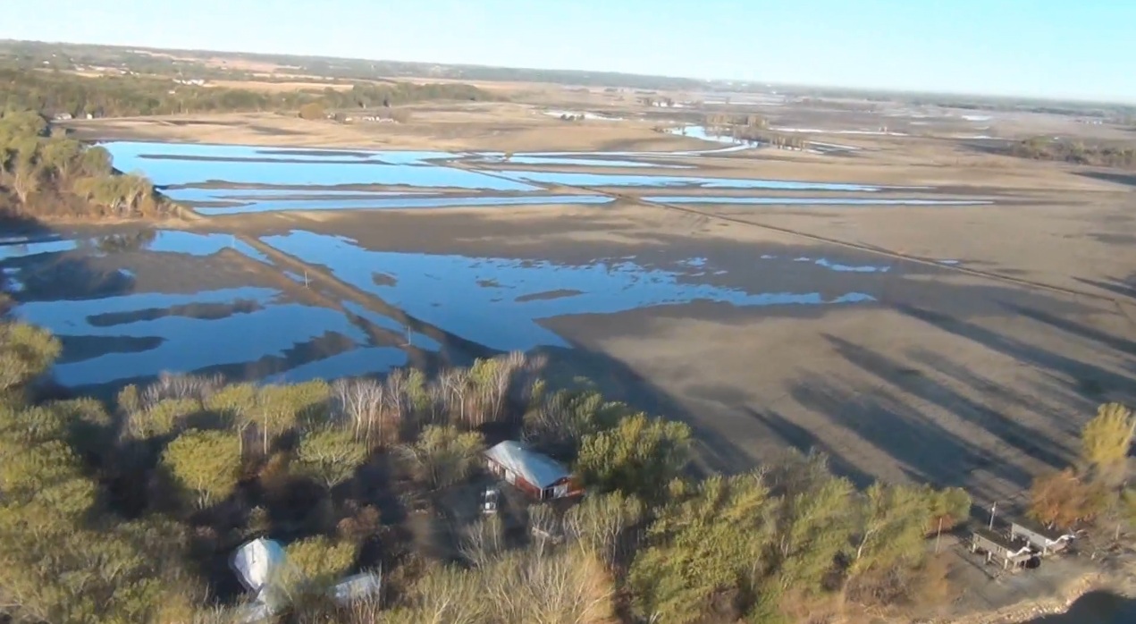
Aerial view of the floodplain south from Nathans Lake. Image from video taken October 15, 2011 by the Army Corps of Engineers, during a flight from Omaha to Decatur.

07 October 2011

Flooded Corn-fields Ephemeral Habitat on Missouri River Flats

What is typically corn fields south of Bellevue was flooded in late summer and early autumn of 2011, the year of the great Missouri River flood. Standing water were wetlands utilized by various species of birds as the conditions were suitable for them to reside and feed.

It wasn't until mid-September that any bird use features were determined for the flat land along the east and west sides of Harlan Lewis Drive. This area is on the north side of the Big Papillion Creek. On the south side of the creek are the well-known La Platte Bottoms, a locale which has not been accessible for months due government-enforced road closures.

When the aberrant wetlands were first noted, there was an extensive amount of standing water being used by different sorts of fowl. It was early in the autumnal migration season. Blue-winged Teal were the most prevalent this day, along with numbers of swallows and a few other unusual species such as the Yellow-headed Blackbird.


There were just a few subsequent visits reported for this place. Overall there were 27 species denoted as indicated by a summary of available records contributed by a two or three area bird-watchers and as determined from personal visits. Other observers are known to have also visited the locale, but their observations were not reported.

Common Name

9/17/2011

9/28/2011

10/1/2011

10/5/2011

Wood Duck

- -

- -

- -

8

Gadwall

2

- -

- -

- -

Mallard

26

- -

- -

2

Blue-winged Teal

235

- -

- -

7

Northern Shoveler

- -

- -

50

8

Northern Pintail

- -

- -

3

- -

Pied-billed Grebe

6

- -

3

- -

Great Blue Heron

5

1

- -

- -

Osprey

- -

- -

- -

2

American Golden-Plover

- -

45

- -

- -

Killdeer

8

- -

65

55

Lesser Yellowlegs

- -

10

2

- -

Pectoral Sandpiper

30

11

3

- -

Stilt Sandpiper

- -

2

2

- -

Long-billed Dowitcher

- -

15

- -

- -

Franklin's Gull

1

- -

- -

- -

Ring-billed Gull

1

- -

- -

- -

Belted Kingfisher

1

- -

- -

- -

Northern Rough-winged Swallow

100

- -

- -

- -

Barn Swallow

100

400

200

40

Marsh Wren

- -

- -

1

- -

American Robin

- -

- -

- -

35

European Starling

- -

- -

- -

350

Red-winged Blackbird

100

- -

- -

20

Yellow-headed Blackbird

6

- -

2

- -

Common Grackle

- -

- -

- -

100

Brown-headed Cowbird

30

- -

- -

- -

These records indicate the avian use of ephemeral habitat resulting from flood conditions at lowlands along the Missouri River in eastern Nebraska.

On the last visit noted, a rapidly shrinking extent of standing water remained. There was a large extent of barren and dry ground. The influence of the flood waters was rapidly diminishing. Killdeer were still abundant. Few waterfowl were about and their numbers was dramatically exceeded by the swarming starlings and grackles.

The highlight of an evening visit was two Osprey. One carried a fish as it looked for a handy spot to eat an evening's meal. A second Osprey was still looking for a fish of some sort stranded among the few bits of remaining water.

There will be plenty of frogs left without any water in the pending days as the unsually dry and warm weather conditions continue.

There is little if any information to report on how flood waters created conditions suitable elsewhere which may have been used by migratory birds. The impact of the great flood has been a tragedy for many people along the river, yet it should also be noted that other results of the situation can also be considered. The riverine flows unsurpassed in the past few years have provided a variety of habitat in many places for Missouri River birdlife, perhaps representing the situation once prevalent when the river was not channelized.

23 June 2011

Water Spreads Across Missouri Floodplain

View of Tobacco Island mitigation area. Image courtesy of the Army Corps of Engineers.

"Floodplain functionality" has dramatically returned at wild lands along the Missouri River as evident at the numerous mitigation areas created by the U.S. Army Corps of Engineers during recent years.

Most of the sites adjacent to the river channel are now completely inundated by flood waters, based on river valley inundation maps prepared by the Corps.

Many of these mitigation sites including land that was formerly corn fields, which would have been inundated under current conditions along the river.

The depth of water at the mitigation sites would vary, according to Jolene M. Hulsing, a natural resources specialist with the Corps' Omaha district.

"The Corps number one concern is public safety and property," Hulsing said, "The flood will expose mitigation sites to natural processes that facilitate fish and wildlife.

"Mitigation sites serve as areas for the river to flow where it did prior to construction of navigation controls. These areas have been reconstructed to 'mimic' natural conditions. Being exposed to this rare flood event exposes the sites to pre-navigation and pre-dam flows. How the landscape responds to the flood water will be reminiscent of how the landscape functioned prior to settlement.

"It will be educational to see what the flood has done to impact these sites," she said.

A thorough evaluation of the sites will occur once the flooding has ended.

"Vegetative conditions and wetland situations will be mapped," Hulsing said.

There will most likely be damage to infrastructure at the mitigation sites, such as pumping stations, rock structure, fencing, roads, signage, etc. Hulsing said. "This will all have to be assessed after the flood water recede."

Corps officials currently have only limited access to the mitigation areas, due to inundated roads and excessive flows which severely inhibit boat or vehicular access.

Hulsing and other staff at the Missouri River Project Office have had to relocate from their headquarters at the Omaha Moorings, along Pershing Drive. Water is inside the lower buildings, but a port a dam currently is keeping water out of the Administrative office.

Local wildlife is having to adapt to the higher flows, but the river's fish and wildlife has dealt with flooding along the river for centuries. The extent of the spreading water may be a new experience for current generations, so they are being forced to adapt.

The mitigation sites from Sioux City to Rulo comprise about 22,000 acres, and are actively managed for natural uses to benefit indigenous fish and wildlife.

20 June 2011

Editorial Cartoonist Erroneous

The editorial cartoonist for the local daily newspaper was off the mark on the strip for June 15, 2011.

This strip is wrong in many ways by what it conveys, including:

  1. Indicating that extensive flooding was the result of water management for endangered and threatened species
  2. Conveying a perspective that people were suffering due to birds and fish
  3. Is a lame commentary attacking fish and birds which have few advocates for their interests
  4. Shows a disregard of the need for conservation of important natural resources within the Missouri valley
  5. Does not convey that the bird species have also lost their seasonal homes

For these reasons, the artist was nominated as a "butthead of the week" on the Tom Becka show, on Friday evening, June 17. The talk-show host also tried to make the discussion one of birds versus people.

This erroneous perspective shows a lack of awareness and is an easy stance to take rather rather than to understand the issues. There are compromises involved and finding common ground is preferable to antagonizing the situation.

This cartoon is included through the fair-use provision of the copyright law.

13 June 2011

Malaise of Flooded Missouri Valley Habitats

A white-tailed deer belly-deep in flood waters covering the Horseshoe Lake Flats was the forlorn sign of the malaise along the in bird habitats along the Missouri River of Nebraska. It stood still for quite a time, not moving in any particular manner, as if not knowing what to do next. It was surrounded by water of variable depths, and may have lost its nurtured fawn?

For wild birds, there have undoubtedly been similar tragedies of the summer breeding season as merciless water creeps across dry land, flooding habitats and havens for so many birds.

Carbonation

A visit to some known floodplain places was carried out on June 11th.

It started with an arrival on the east bluff lookout at Hummel Park a bit after 5 a.m., to have proper siting for a sunrise during the summer solstice month. Access was available from Ponca Road as Pershing Road was closed at the river bridge near Florence. Above this road, the Interstate had also been closed, as flooding on the Iowa side meant a closed section of I-29.

Along the steep route outward, the clay soil was tacky, giving a good grip for shoe soles, and thankfully suited for the careful steps to get along on a suitable vantage point or two.

Upon looking downward in a vast expanse, an Eastern Phoebe found the situation suitable, though it was a place where an errant step would be into a dangerous, big hole or a long fall from the sheer bluff wall.

Songsters expressed the pending day, vocal in a scene without car or plane traffic. Fog in the sky masked portions of the Missouri valley in the dim and expressive light of pre-dawn.

The lowland was liquid H2O, mostly covered.

The corn field to the east was mostly flooded, with another Duda Farm field to the north was entirely flooded. N.P. Dodge Park was all covered. Scant glimpses of sun and changing sky conditions meant it was time to relocate.

A quick jaunt was made to the Horseshoe Lake Flats. Along the way - after the dreadful traffic control situation due to recreational trail construction - the Surfside Club was closed due to flood conditions, especially in its parking lot. The usual road taken along the lowlands by the Krimlofski Tract was closed and blocked by cement barricades. An alternative western route was taken that ended at the drainage ditch along County Road P49. Where it was barricaded, with signage.

Floodplain

Nearly everything eastward of this point was under some depth of water. It looked like a lake to the east, though the road signs sticking up here and there readily indicated usual purposes. In the distance were inundated buildings. A center-pivot irrigator was useless as it was partially under water.

The most interesting consideration from this point: What is the entire flooded land was actually part of the Boyer Chute NWR. Forget growing crops on a floodplain but allow the river to reclaim land it undoubtedly spread across in former years. The scene was wild and dramatic in its presentation of a time many decades ago when there was natural flooding which was the nature of the Missouri River.

Resident tragedies would eventually disappear. There would be less personal disasters and economic impact if the land was managed differently.

After an interlude, the day's route went southward to the entrance of N.P. Dodge Park where the local flock of Canada geese were gathered. The gaggle of geese were gathered on a spit of grass. One gander was using a spot reserved for handicapped parking. Boisterous goslings were big but not yet ready to fly. This bit of turf was among the few square feet of the park which were not inundated.

Displaced

An unusual bird sighting here was two Green Herons, also adapting to the conditions. A Killdeer had a miniscule place where it could forage.

Along Pershing Drive, a jogger came along, and upon inquiry said there was no water on the road to the south. That route was actually accessible. Here, and elsewhere during the day, were gawkers getting their own perspective of the Flood of 2011.

Returning to the Hummel Park bluffs, intermittent sun and fog clouds presented a suitable dichotomy of the situation.

After safely maneuvering the park bluffs - more suited to a phoebe or bunting than a human hiker - it was time to go further south, moving first along Pershing Drive. The Corps of Engineers had built a berm of several feet around the Omaha Moorings staff building. Coast Guard people had done the same. Beneath the Mormon Bridge, a officer of the Omaha Police Department sat in his cruiser, controlling inbound access onto the drive. Leaving was not being controlled.

The guy was given a wave.

Near Carter Lake, contractors were placing sand bags around at least four electrical facilities - transformers, etc. - along Abbott Drive, by Eppley Airfield. Preventive efforts certainly?

Industrial?

La Platte Bottoms

Safely transversing the traffic officer radar spot north of La Platte, the always expressive La Platte Bottoms were reached. Water levels were notably higher than an earlier visit in June. There were however, barricades and road closed signs at the junction of La Platte Road and Harlan Lewis Drive, similar to those from the latter months of 2010.

Upon driving east to see what birds were about, my excursion was brought short by a man in a big pickup, making a kindly gesture. He asked if my residence was further along? No. He then said the county sheriff was issuing tickets to people present along the road, as it was officially closed. The apparent fine was $57.

My route - after noting the Great-tailed Grackles - went eastward to the first turn-around and continued to a stopping point at the intersection, just a few feet west of the barricades and signs, and certainly out of the zone of potential conflict.

It was not a good time to be trying to watch birds. There was too much traffic, especially dump trucks of various sorts. Some were taking fill material to a nearby site along Papillion Creek where the military was apparently filling sand bags to armor the creek's levee. A bit west, other trucksters hauled quantities of dirt to create a berm around a power company facility.

During a stop at the western edge of the bottoms, with the car parked completely off the roadway, there was a bit of time to see more Black Terns, and snap a pic after getting stable following the gusts from passing trucks. While there, a county sheriff drove past.

Watersway

Great Marsh

The road to the floodplain of Fontenelle Forest and Gifford Point was completely blocked by barricades about a mile to the west, near Camp Logan Fontenelle. There were four barricades joined by a cable preventing any vehicular access, though there were no directives limiting foot traffic.

It did require a hike among the forest with beautiful birds to arrive on the floodplain. There certainly was water on the road, a few hundred feet eastward of the railroad tracks. Most of the lowland of Gifford Point is covered by some extent of river flows at this place directly below the city of Omaha.

The Great Marsh is greater than it has been in any recent year. The expansive marsh includes aquatic forest to the east - perhaps it might be called a swamp - and there are probably continuous liquid conditions to Hidden Lake.

Rust on the tracks indicate a lack of use for the BNSF railroad line.

Evening Time

Barricades along the county road east of Fort Calhoun were noted in a visit during in the early evening with ample sun. A partial barricade was bypassed to access to the barricade point. During the very brief visit, a patrol car of the Nebraska State Patrol came on the scene, but left without asking any questions.

A second visit to CR P49 indicated an increase in water levels. The bit of road present in the morning - as used by foraging Common Grackles and Killdeer - was gone. A female gawker here would not go beyond the barricades and signage because it said no trespassing.

The day went smoothly with no harangues for being anyplace. No inadvertent mishaps. And any citations for trespassing or speeding were avoided. All it took was time and money for high-priced gasoline.

Flood. Original artwork (c) 2011 Scott Malone.