History for these districts notably began at the outlet of Hog Island Lake on November 6, 1915. Ranchers in the region northward of Irwin had discussed how to drain meadows for many years previous, and had undertaken individual efforts, but they realized that a group effort would be required.
The Horseshoe Lake Drainage District was then established in northwest Cherry county within T34N, R39-40 W. A drainage system survey was done during the autumn of 1915 to determine a suitable route to facilitate water drainage.

This plan was discussed by the Cherry county commissioners on April 4, 1916.
Drainage conditions in dry years were noted to be sufficient, “but such dry seasons are rare and not so frequent as to warrant the present conditions to go on,” according to the county record chronicles.
“At the present time, more than 1/3 the normal hay crop is under water. This means considerable expense and annoyance to the ranchers.”
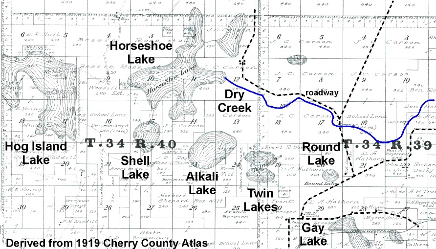
From Hog Island, and eastward through the hills, a survey was done to determine a route for a ditch to drain the water away, and along a route which would eventually connect to Dry Creek, a natural waterway.
“The purpose of this drainage project will be to reclaim the hay land that lies along the lake borders and under the overflow. With the exception of Shell Lake and about 100 acres of Horse Shoe all the land shown on the map as under water is hay land, envolving [sic] 3000 acres.
“The problem then is to lower the lakes sufficiently to ranch all the hay be cleaning out the present natural water course which already carries water except for a few hundred feet at the outlet of Horse Shoe Lake,” the proposal indicated.
“The number of acres of hay land released by this proposed system is safely 3000 acres. Considering that the average yield is 1 1/4 tons per acre it will yield 3700 tons of hay which is worth $2.00 a ton uncut or $7,500.00 This is therefore the value that can be placed upon the increased hay crop every year by reason of drainage. From this amount may be subtracted 2% for maintenance which leaves $7350.00. The cost of the project is estimated at $26,796 94/100 making the cost $6.62/100 per acre. $7350.00 is 27% of the capital involved. This money is not capable of earning more than 10% in first farm mortgages, or 7% in the bank.”
It required 117,800 linear feet (ca. 22.3 miles) of ditching from upper Hog Island, at Shell Lake, to Brush Lake, through Horseshoe Lake, to Wood Lake and past Slim Lake to the creek. The cost was indicated as an estimated $25,797 or an average cost of $8.82 per acre.
Primary beneficiaries would be J.C. Carson (797.72 acres) who would become president of the drainage district board, Mrs. Bessie Ross (494.24 acres), Irwin Ranch (342.18 acres), Wilbur Young (220.61 acres), Elizabeth Florey (179.65 acres) and others of a lesser extent. Charles E. Potts would become secretary for the district, with Pleasent Robertson a director.
A resident in the area, Benjamin Roberts did unsuccessfully object to the formation of the district. There were seven reasons listed in his report presented to the county board of commissioners, which at the time were J.A. Adamson, D.M. Sears and Arthur Bowring. Robinson stated that the board had no jurisdiction in approving the establishment of the district. Another item was that land owned would not receive any benefits, though he would hay to pay district assessments, and “great and heavy damage” to his hay lands.
The claim was found to not have any standing.
By November of 1916, contracts were written for the digging of nearly 20 miles of ditches to drain away water. The Omaha Steel Structural Works, of Omaha, got one to build two bridges spanning ditches, at a cost of $875. In February 1917, the Fred W. Crane Co., also of Omaha, got the contract to use a floating dredge to excavate ditches to drain away unwanted water. The amount paid would be so much per mile.
The ditch work was apparently not done suitably, however, and the contractor was sued in court in early 1922 for breach of contract. The company claimed it was physically impossible to drain the area, based upon specifications prepared by engineer Paul E. Brown (Omaha World-Herald January 11, 1922). The drainage district stated that the work was started, yet not completed.
Brown was the key witness for the drainage district, and testified for several days, expressing many thousands of words at the Douglas county court, according to the newspaper report.
A verdict of $26,500 was eventually awarded by the jury, in favor of the drainage district. The Crane Co. and its bond company American Fidelity Co. were liable due to the jury verdict.
The extent of drainage associated with Hog Island Lake and Horseshoe Lake is indicated by the 1919 atlas of Cherry county, where the extent of water is shown. These wetlands spread across multiple sections of land, and hundreds of acres, though drawn lines indicated connections between the water areas. These two lakes, on later maps are not shown to be lakes. The areas were converted to a setting that would provide an annual hay harvest from meadow lands.
The Horseshoe drainage ditch is obviously shown on modern-era topographic maps, and is apparently being still being maintained to remove water.
There were other drainage projects in this same region of northwest Cherry county.
Irwin Lake Drainage District
An Irwin lake drainage project in 1922 involved drainage from Gay Lake to Leander Creek. Water would be removed from Gay, Cullison, and Round lakes in the area eastward of Irwin. A petition for the project was made by the Chicago and Northwestern Railway. “Draining would reclaim about 800 acres of swamp land to benefit of owners,” public records indicate. The ditch would go from Gay Lake to Leander Creek.In 1952, a petition to clean the drainage ditches for this district included signatories Dennis Hathorn, Emil Fuscher, Florence Coleman, Henry Hathorn and Anna D. Shadbolt. The cost was $21,826, and which included construction of an additional ditch through Gay Lake.
Boardman Drainage District
A petition to create this drainage district was initiated by John H. Bachelor, resident along Boardman Creek in central Cherry county. The primary landowners were Bachelor and Henry F. Brown. The Boardman Cattle Co. was prominent in the area of concern. Directors of the district board were John H. Bachelor, Chas. Lewis and O.E. Bachelor. Of the 6040 acres within the district, 2450 acres would be “reclaimed,” according to county records. This would require the excavation of about 180,000 cubic yards of earth along a length of about 72,000 feet, or more than 13 miles. The district was primarily within T30N R31-32W.Coffey Lake Drainage District
A 1923 project was initiated within T34N R39W. At an estimated cost of $19,380, the levels of the shallow-water lakes named Coffey, Coates, Grigg and Jarchow would be lowered. This work was done in 1924, at a cost of 22.5 cents per cubic yard excavated for the first 4000 cubic yards, and then 12.5 cents per yard for the remainder as done by Roland C. Franke of Mullen. Expenses for the 1924 work included more than $19,000 for building two bridges across drainage ditches and for excavating 87,401 cubic yards of earth.Hale Lake Drainage District
This district was being established in August-October 1923. Once again, the Chicago and Northwestern Railway Company was the petitioner to drain water within a few sections of T34N R34W. C.C. Goodrich was the property owner. A ditch with a length of 8000 feet at an expense of $8,000 would be used to drain Hale Lake, into Roxby Lake and hence into Goodrich Lake.Mile Board Lake and Walker Lake Drainage District
Located in the vicinity of Eli, in the northern extent of the county, this project of January 1925 to remove water was initiated at the request of the Chicago and Northwestern Railway Company. The ditch would extend from Mile Board Lake southward to a natural waterway, Bear Creek. There would be 30,132 cubic yards excavated on property primarily owned by Arthur Bowring and E.M. Dennison. The Martin Day Co. was the contractor doing the digging.The Modern Era
Most of the early drainage districts are not seemingly active, as there are no county records indicating any assessment of a yearly levy, or budgetary reports.There is still Drainage District No. 100 which includes portions of southwest Cherry county and northern Grant county. Its taxation levy for the years 1975-1979, based upon $1.75 per acre benefitted was $1.75 per acre or a sum of $1,374.65 annually. Three landowners involved in Grant county had an extent of 254 ($444.50 cost) or 94 or 70 acres of benefit. There were 90 and 71 acres benefitted in Cherry county. These figures remained the same for the 2005-2009 levy.
For the years 2015-2019, the levy remained the same. The Grant County News issued a notice of budget hearing and budget summary for its 2016 meeting, denoting a summary of disbursements, fund transfers and the cash reserve. This drainage district is still active in its land changing activities.


