24 March 2016

Drainage Districts of Cherry County Nebraska

Historic times within Cherry county that would alter the landscape were active efforts by groups of landowners wanting to establish local land drainage districts.

History for these districts notably began at the outlet of Hog Island Lake on November 6, 1915. Ranchers in the region northward of Irwin had discussed how to drain meadows for many years previous, and had undertaken individual efforts, but they realized that a group effort would be required.

The Horseshoe Lake Drainage District was then established in northwest Cherry county within T34N, R39-40 W. A drainage system survey was done during the autumn of 1915 to determine a suitable route to facilitate water drainage.


This plan was discussed by the Cherry county commissioners on April 4, 1916.

Drainage conditions in dry years were noted to be sufficient, “but such dry seasons are rare and not so frequent as to warrant the present conditions to go on,” according to the county record chronicles.

“At the present time, more than 1/3 the normal hay crop is under water. This means considerable expense and annoyance to the ranchers.”

From Hog Island, and eastward through the hills, a survey was done to determine a route for a ditch to drain the water away, and along a route which would eventually connect to Dry Creek, a natural waterway.

“The purpose of this drainage project will be to reclaim the hay land that lies along the lake borders and under the overflow. With the exception of Shell Lake and about 100 acres of Horse Shoe all the land shown on the map as under water is hay land, envolving [sic] 3000 acres.

“The problem then is to lower the lakes sufficiently to ranch all the hay be cleaning out the present natural water course which already carries water except for a few hundred feet at the outlet of Horse Shoe Lake,” the proposal indicated.

“The number of acres of hay land released by this proposed system is safely 3000 acres. Considering that the average yield is 1 1/4 tons per acre it will yield 3700 tons of hay which is worth $2.00 a ton uncut or $7,500.00 This is therefore the value that can be placed upon the increased hay crop every year by reason of drainage. From this amount may be subtracted 2% for maintenance which leaves $7350.00. The cost of the project is estimated at $26,796 94/100 making the cost $6.62/100 per acre. $7350.00 is 27% of the capital involved. This money is not capable of earning more than 10% in first farm mortgages, or 7% in the bank.”

It required 117,800 linear feet (ca. 22.3 miles) of ditching from upper Hog Island, at Shell Lake, to Brush Lake, through Horseshoe Lake, to Wood Lake and past Slim Lake to the creek. The cost was indicated as an estimated $25,797 or an average cost of $8.82 per acre.
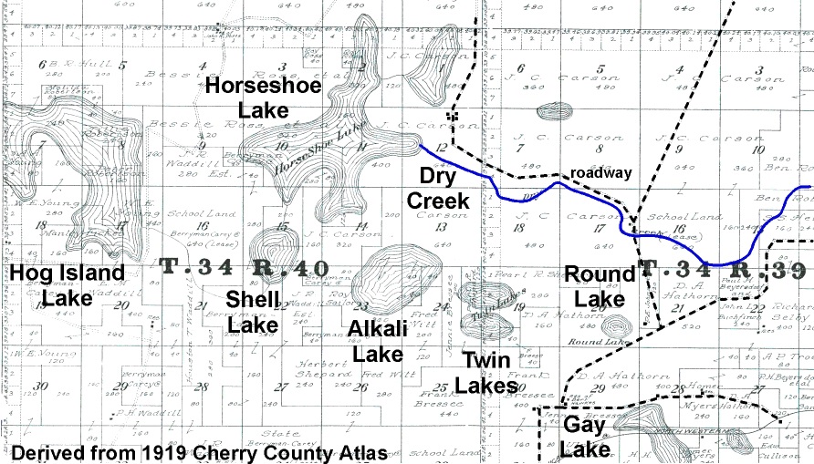
A vote held on June 17, 1916 approved the project. Primary voters were the Berryman-Carey Co. by C.C. Carey, Mrs. Bessie Ross, James C. Carson, W.E. Young and many of the about twenty landowners within the district.

Primary beneficiaries would be J.C. Carson (797.72 acres) who would become president of the drainage district board, Mrs. Bessie Ross (494.24 acres), Irwin Ranch (342.18 acres), Wilbur Young (220.61 acres), Elizabeth Florey (179.65 acres) and others of a lesser extent. Charles E. Potts would become secretary for the district, with Pleasent Robertson a director.

A resident in the area, Benjamin Roberts did unsuccessfully object to the formation of the district. There were seven reasons listed in his report presented to the county board of commissioners, which at the time were J.A. Adamson, D.M. Sears and Arthur Bowring. Robinson stated that the board had no jurisdiction in approving the establishment of the district. Another item was that land owned would not receive any benefits, though he would hay to pay district assessments, and “great and heavy damage” to his hay lands.

The claim was found to not have any standing.

By November of 1916, contracts were written for the digging of nearly 20 miles of ditches to drain away water. The Omaha Steel Structural Works, of Omaha, got one to build two bridges spanning ditches, at a cost of $875. In February 1917, the Fred W. Crane Co., also of Omaha, got the contract to use a floating dredge to excavate ditches to drain away unwanted water. The amount paid would be so much per mile.

The ditch work was apparently not done suitably, however, and the contractor was sued in court in early 1922 for breach of contract. The company claimed it was physically impossible to drain the area, based upon specifications prepared by engineer Paul E. Brown (Omaha World-Herald January 11, 1922). The drainage district stated that the work was started, yet not completed.

Brown was the key witness for the drainage district, and testified for several days, expressing many thousands of words at the Douglas county court, according to the newspaper report.

A verdict of $26,500 was eventually awarded by the jury, in favor of the drainage district. The Crane Co. and its bond company American Fidelity Co. were liable due to the jury verdict.

The extent of drainage associated with Hog Island Lake and Horseshoe Lake is indicated by the 1919 atlas of Cherry county, where the extent of water is shown. These wetlands spread across multiple sections of land, and hundreds of acres, though drawn lines indicated connections between the water areas. These two lakes, on later maps are not shown to be lakes. The areas were converted to a setting that would provide an annual hay harvest from meadow lands.

The Horseshoe drainage ditch is obviously shown on modern-era topographic maps, and is apparently being still being maintained to remove water.

There were other drainage projects in this same region of northwest Cherry county.

Irwin Lake Drainage District

An Irwin lake drainage project in 1922 involved drainage from Gay Lake to Leander Creek. Water would be removed from Gay, Cullison, and Round lakes in the area eastward of Irwin. A petition for the project was made by the Chicago and Northwestern Railway. “Draining would reclaim about 800 acres of swamp land to benefit of owners,” public records indicate. The ditch would go from Gay Lake to Leander Creek.

In 1952, a petition to clean the drainage ditches for this district included signatories Dennis Hathorn, Emil Fuscher, Florence Coleman, Henry Hathorn and Anna D. Shadbolt. The cost was $21,826, and which included construction of an additional ditch through Gay Lake.

Boardman Drainage District

A petition to create this drainage district was initiated by John H. Bachelor, resident along Boardman Creek in central Cherry county. The primary landowners were Bachelor and Henry F. Brown. The Boardman Cattle Co. was prominent in the area of concern. Directors of the district board were John H. Bachelor, Chas. Lewis and O.E. Bachelor. Of the 6040 acres within the district, 2450 acres would be “reclaimed,” according to county records. This would require the excavation of about 180,000 cubic yards of earth along a length of about 72,000 feet, or more than 13 miles. The district was primarily within T30N R31-32W.

Coffey Lake Drainage District

A 1923 project was initiated within T34N R39W. At an estimated cost of $19,380, the levels of the shallow-water lakes named Coffey, Coates, Grigg and Jarchow would be lowered. This work was done in 1924, at a cost of 22.5 cents per cubic yard excavated for the first 4000 cubic yards, and then 12.5 cents per yard for the remainder as done by Roland C. Franke of Mullen. Expenses for the 1924 work included more than $19,000 for building two bridges across drainage ditches and for excavating 87,401 cubic yards of earth.

Hale Lake Drainage District

This district was being established in August-October 1923. Once again, the Chicago and Northwestern Railway Company was the petitioner to drain water within a few sections of T34N R34W. C.C. Goodrich was the property owner. A ditch with a length of 8000 feet at an expense of $8,000 would be used to drain Hale Lake, into Roxby Lake and hence into Goodrich Lake.

Mile Board Lake and Walker Lake Drainage District

Located in the vicinity of Eli, in the northern extent of the county, this project of January 1925 to remove water was initiated at the request of the Chicago and Northwestern Railway Company. The ditch would extend from Mile Board Lake southward to a natural waterway, Bear Creek. There would be 30,132 cubic yards excavated on property primarily owned by Arthur Bowring and E.M. Dennison. The Martin Day Co. was the contractor doing the digging.

The Modern Era

Most of the early drainage districts are not seemingly active, as there are no county records indicating any assessment of a yearly levy, or budgetary reports.

There is still Drainage District No. 100 which includes portions of southwest Cherry county and northern Grant county. Its taxation levy for the years 1975-1979, based upon $1.75 per acre benefitted was $1.75 per acre or a sum of $1,374.65 annually. Three landowners involved in Grant county had an extent of 254 ($444.50 cost) or 94 or 70 acres of benefit. There were 90 and 71 acres benefitted in Cherry county. These figures remained the same for the 2005-2009 levy.

For the years 2015-2019, the levy remained the same. The Grant County News issued a notice of budget hearing and budget summary for its 2016 meeting, denoting a summary of disbursements, fund transfers and the cash reserve. This drainage district is still active in its land changing activities.

16 March 2016

Sky Birds of Late Winter

As temperatures have warmed in recent days, a variety of bird sounds have become obvious among the habitats of Valentine.

The Eurasian Collared Doves have been especially expressive while staking a claim on a breeding space, within town and northward about the Mill Pond. The few bright red cardinals can be heard early in the morning.

Robins are actively establishing their claim to a breeding space. They have been noted upon one fence or another, just a few feet apart, while they hop around - a few feet apart - to establish territorial dominance. Bald eagles are sitting on their nest. Red-tailed Hawks have their place to nest. Owls are also involved, caring for their early season nest.

Especially subtle and exquisite during these spring times is the bird with a cerulean color that mimics the hue of the day's sky. The dramatic featheration of the blue bird is distinctly unique. The feathers are at their prime as the males express the claim to a territory for this season.

The Eastern Bluebirds arrived with warmer weather. They perch atop tree snags, upon utility wires, fences or other land features while being focused upon finding something edible, notably early season insects.

The coloration of these birds is dramatic as they renew their residence. The vivid blue on their back is enhanced by a brown and white chest. Their song is a pleasant phrase of soft whistles, that spreads across their chosen territory.

Females have lesser in color but are most essential for the coming breeding season.

When seen near to the other, the larger robin seems to not only have a lesser quality of a song, but also looks rather drab in any comparison of coloration.

Bluebirds are regular residents on the north side of Valentine, and elsewhere. Their daily activity can be enjoyed as a special treat these early days of an ascending spring. Placing a nest box in suitable habitat can be a way to welcome a pair to raise a brood. Their beauty is something for any avian aficionado to appreciate.

Winter is not yet done, as several Dark-eyed Junco are still seen on a daily basis, as they search for food.

Soon the wrens will arrive, and they will gather among the many nest boxes prevalent on the north side of the Mill Pond. There will soon be a plethora of wrenly activity because there are a big bunch of nest boxes where they can raise a brood.

Spring has arrived and any bird enthusiast can take their binoculars and look upon their back yard, the city park or most any place to appreciate the season's birds. Notable places within walking distance include the Mill Pond, city park and the fish hatchery. Valentine has many wild places to enjoy birds!

05 March 2016

Gordon Creek Restoration Project, Cherry County

A partnership project along Gordon Creek in central Cherry county has restored historic channel features with a benefit to adjacent wetlands.

The project is located near Aljo Hill and on the Spikebox Ranch, a Sandhills Ranch property owned by R.E. Turner. Other partners in the already completed project were the Nebraska Game and Parks Commission, Sandhills Task Force and U.S. Fish and Wildlife Service. The Natural Resources Conservation Service did the delineation of wetlands and established design details.

The project evaluation and design and overall consultation by partners occurred during a twenty month period, with official consent signatures by the landowner and agencies occurring during the latter part of 2014, according to primary specifics available within an Army Corps of Engineers document, as received through a Freedom of Information Act request.

The work reverted the creek from its channelized condition to its original, historic channel with its meanders, permanent flow and adjacent wetlands.

The project involved waterway meanders and length, increasing 5750 feet of Gordon Creek to a length of 42,300 feet, by placing 22,456 cubic yards of fill into existing channel to redirect the water flow into the historic channel alignment, as well as excavating 16,920 cubic yards of material within the historic channel to facilitate water flow. Existing drainage ditches were also filled, with berms placed where needed. Stream crossings for vehicles were also changed.

A grade stabilization structure was also built at the eastern end of the project to inhibit stream-bed degradation. Concrete block mat and turf reinforcing mat was also installed for ground stabilization purposes.

The indicated project cost was $215,000. Funding sources were $100,000 from the Nebraska Game and Parks Commission through a state wildlife grant received from the U.S. Fish and Wildlife Service; $60,000 from the Sandhills Task Force as provided through a grant from the Nebraska Environmental Trust; $40,000 from landowner R.E. (Ted) Turner; and, $15,000 from the U.S. Fish and Wildlife Service.

Monitoring reports are required through 2020 to ensure that goals stated in the Corps of Engineers permit are met. A permit for project construction was issued in June, 2015 after Section 404 consultation with the Sandhills Ranch Properties of Turner Enterprises, Inc. The NGPC submitted the permit application.

Additional FOIA requests for project details as submitted in mid-January to the Natural Resources Conservation Service and U.S. Fish and Wildlife Service have not resulted in receiving any project documentation from either agency, as of March 1st.

17 February 2016

Historic Longhorn Occurs at Valentine Livestock Market

A distinctive Texas longhorn with origins associated with a cattle herd with decades of legacy recently occurred at the Valentine Livestock Market.

The large and lively steer of expressive coloration was sold February 11th during a Thursday weigh-up sale. It weighed 1420 pounds, and was purchased for $284, or 20 cents per pound, according to market records.

A US brand was obvious on its left rear hip. This is the mark used for the longhorn herd that was formerly at the Fort Niobrara National Wildlife Refuge.

The animal was immense, with a magnificent set of horns gracing its about six foot stature. While at the market it was notably cantankerous, resulting in an obvious awareness of its presence in one pen or another. Its antics also elicited some "funning" by pen workers on sale day, as it seemed to act in response to the red coloration of a coat. During some other times while constricted among the stock pens, it could be relatively calm.

This steer was taken from its home on the range to a pen at the livestock market, upon delivery for sale by a rancher of southeast Cherry county, westward from Brownlee. It had been kept in a pasture amidst other ranch bulls, according to its former owner. The estimated age was 12-14 years, he said. It was bought as a calf of the year during a longhorn sale at Fort Niobrara refuge.

This steer may have been one of the last longhorns born at the refuge, according to historic details available from numerous sources.

The last longhorn calf crop at the refuge was in 2000. They were branded June 4th, according to historic articles and records. At the last annual auction in October, a variety of longhorns from the herd were sold, including all of the bull and heifer calves. It cost, on average, $663 to purchase a bull calf.

Later in the month, a memorandum of understanding denoted those longhorns to be transferred from U.S. Fish and Wildlife Service ownership to the Nebraska Game and Parks Commission. No calves were included.

In mid-November 2000, the remaining herd with origins dating to the mid-1930s, were moved in a great and famous overland drive from the refuge east of Valentine to Fort Robinson state park.

Since the herd was gone from the Valentine area in 2000, the steer at the market was at least 15 years old, and may have been 16 this coming spring, if not older.

On February 15th, this iconic longhorn - along with other sold cattle - were loaded on a semi-truck trailer and departed Valentine, with Texas the destination.

February Weekend Birds at Valentine

Records of bird sightings kept during the weekend of the Great Backyard Bird Count indicate the typical birds of the late winter season at Valentine. There was not a great variety observed in the area, most notably around the Mill Pond and city park during the very variable weather of the count weekend. Despite the low diversity, there was still a lot of bird activity.

The most prominent fowl were the skeins of flying Canada Goose, with hundreds congregating at the Mill Pond, spending the night on the ice near the always not frozen Minnechaduza Creek. They venture northward daily, usually an hour or two after sunrise, to places where there is apparently ample food. Others seemed to be flying in from southward places, adding to the throng.

At the pond during the weekend were six Mallard sitting on the ice.

Early on Saturday, the 13th, an adult Bald Eagle soared above the pond, searching for its meal of the day. It certainly was not flying around to get a good view of the cattle in the Bull Bash pens.

The remainder of the bird life seen during the count days are regular seasonal residents.

The tally included the Red-tailed Hawk at the park. The usual Rock Dove within Valentine especially linger about the livestock market. Some Eurasian Collared Dove are especially vocal, and are notably the first heralds of spring, with some obviously cooing along north Main street, as they establish a breeding season home with their mate.

Red-bellied Woodpecker are always heard in a vivacious manner on one tree snag or another. Add to the tally, the Downy Woodpecker, Hairy Woodpecker. Northern Flicker, Blue Jay and flying boisterous American Crow.

There were about a dozen Cedar Waxwing enjoying a seed source within the city boundaries as the weekend was starting.

Small yet expressive Black-capped Chickadee are usually heard saying “hello” when heard and are a cherry resident. A similar tree-bark feeder are the White-breasted Nuthatch which is a prevalent neighbor, being seen or heard at nearly every locality visited during weekend hikes.

A bunch of American Robins were obvious within town at the start of the weekend.

Additional species noted were are the still gathered House Sparrow, itinerant House Finch, American Goldfinch at the feeder on the 400 block of north Main Street, and the darting Dark-eyed Junco. A single, appreciated Northern Cardinal lingered around the Mill Pond. This red bird has not been heard singing, so its spring perspective remains to be heard by an attentive bird watcher.

Warmer weather brought an Eastern Bluebird on February 17th.

12 February 2016

Initial Assessment of Cherry County Document Storage and Conditions

Prepared by James E. Ducey for the Cherry County Commissioner meeting on February 9, 2016 [and as copies of the single page document were provided to each commissioner, with an ensuing discussion during the morning of the meeting at the county building on Main street]

A quick review was done of Cherry County documents stored in the basement of the county building was done January 29th by Jim Ducey and Betty Dougherty, the gracious county assessor. About thirty minutes were spent looking at the material to get an initial sense of the historic material present and the storage conditions.

There are many stored items of obvious historic importance, including:
* Personal assessment records, grouped by precinct [or village in one case, i.e., 1927], dating back to at least 1915
* Pauper register
* Coyote bounty payment booklets of the 1920s and 1930s tied together by twine, while strewn on a shelf
* School attendance records
* Minutes for annual budget meetings for rural schools, including figures on budgeted costs and other distinctive details associated with student education
* Record of discharge for some veterans
* Soldier’s relief warrants from the early 1900s though at least the next few decades
* Treasurer’s cash book
* Improvement schedules for particular ranches in the different county precincts (i.e., 1945)
* Physician register indicating doctors that could practice within the county
* Records of liens placed upon personal property when a bank loan was issued
* Register of shipments of intoxicating liquors
* A box of microfilm records from 1955 to ca. 1970s, which may be assessment records
* Other unknown material that has not been cataloged by county officials now responsible for protecting public records
Two examples of stored material as observed January 29th. Note how some of the items are not properly placed on the shelves or are being stored in dusty conditions. This is not a suitable situation for archiving records, and immediate improvements are necessary.

Numerous conditions not suitable for long-term conservation were: 1) pervasive dust on the material and no measures underway to limit its future accumulation; 2) unsuitable organization of material with different dates placed in no organized manner; 3) presence of bugs, including dead box elder bugs; 4) unsuitable placement of material on a limited extent of shelves; 5) Record items stored in former paper boxes without any organization or identification; and, 6) metal paper clips used on paper material which taints the document quality. These conditions were most obvious. Also, some census records are being kept outside the primary storage area.

In order to properly conserve these public records efforts need to occur immediately to suitably identify and organize the material and find permanent storage facilities in order to permanently protect the paper-based documents. This effort should focus first on items with a greater value (i.e., some ledger books have more entries than others which might have only a few items denoted).

Deed records and many other essential sources of county history are readily available at an office within the county courthouse. The records can be easily found and evaluated whenever the office is open. Why is it that other material of similar origin and importance requires a specific request due to limitations on access as they are kept unrecognized in the basement of the court house? County record keeping is selective and seems arbitrary.

This history of Cherry county needs to have secure and readily available public access for residents and visitors so research can be easily done, without onerous limitations on access. A catalog is an essential need, yet no efforts are underway to provide this source so people know what to request in their endeavor to learn more about the vivid history of Cherry county and its people.


No measures to improve storage conditions of these unique documents were initiated at the February 9, 2016 meeting by the three county commissioners. One commissioner was not aware of the several points made in a document provided December 29, 2015 to the county clerk for presentation to the commissioners. There has never been any action taken in response to an email from a UNL professional, also provided to the commissioners in early January 2016. During the discussion the point was made that the recently enacted protocols for access just need to be followed. My response was: how can someone request particular records if they do not know what records are available. There was an agreement that time would be provided on a limited basis by the county assessor or alternatively the county clerk to allow further review of the records in the basement, to evaluate what is present to facilitate record access requests.


This is how the presentation was indicated in the minutes of the county commissioner meeting.

County assessor Betty Dougherty and Jim Ducey addressed the Board regarding archived County records. Mr. Ducey presented a written initial assessment of document storage and conditions, primarily in the basement of the Courthouse. He identified some conditions that might not be suitable for long term preservation of the material. He encouraged the Board to consider cataloging the records and improve the storage and public accessibility of the records. No formal Board action was taken at this time. Valentine Midland News, February 17, 2016; page 8.

Viaero Response to Comments on Arabia Tower

These are the responses provided to pre-hearing comments by a “site acquisition specialist” for Viaero Wireless as provided to the Cherry county zoning administrator. The comments are based upon a February 4, 2016 document provided to this county office prior to a public hearing of the county planning board. Each item noted in the per-hearing document was individually considered.
The following is a verbatim response to indicated questions.

"Subject: VIAERO WIRELESS Valentine, NE Southeast Site

"In response to Mr. Ducey's List of Questions (see attached numbered Questions,) I am responding with the following Answers.

"1. The Site is somewhat ½ way between our Valentine Site and Wood Lake Site where Frequency Strength needs to be centrally improved.
"2. An Alternate Location is not needed if a Landowner is open-minded to the improvement being close to his/her Headquarters, Hwy. 20 & Cowboy Trail where the Public can depend on the GSM Network.
"3. Viaero Wireless has a Programmatic Agreement with the U.S. Fish & Wildlife. U.S. Fish & Wildlife does not have any concerns if we follow their requirements.
"4. Nebraska Game and Parks were contacted. * See executed Cowboy Trail Crossing License and Nebraska Game and Parks Commission Cowboy Trail Encroaching License Agreement.’
"5. The impact is to the Publics’ Advantage where the increased Frequency Strength will improve the performance of the Hand-Held Device if they are a GSM Customer.
"6. Yes, the Improvement will be seen from Hwy. 20 and Cowboy Trail.
"7. FAA's Determination Letter states the Tower does not need to be lighted/marked and is safe for Air Navigation. Motion Lights will be installed on the Aggregate Building.
"8. I am not aware of the Number of Sites, but w/the size of Cherry County, NOT ENOUGH!
"9. I am not aware of the different Types of Towers and Monopoles in Cherry County. They were all constructed to meet Local, State & Federal Guidelines.
"10. 'Degradation' is a Term from Personalities 'Attitude', if not proven. Personally, there is not much difference of a Cell Tower, Wind Generator, Gran Bin Facility w/a tall Elevator Leg, Electrical Substations, Etc. ..., when comparing their needed Uses and Benefits.
"11. U.S. Fish & Wildlife has studies on this item. If they were concerned, we would've received correspondence from them.
"12. U.S. Fish & Wildlife is aware of this item. If they were concerned, we would've received correspondence from them. This Tower will not have any Guyed Wires.

"I am looking forward to the rescheduled Planning Commission's Public Hearing with their Recommendation forwarded to the County Board of Supervisors."


The planning board will meet on February 22nd, at 4:00 p.m. at the county office building.