29 October 2011

Birdly Wonders of Saturday Morning Along Eastern Nebraska

The following notations indicate the wonderful variety of species about on the morning of Saturday on 29 October 2011. The outing started at north downtown to quickly check for bird strikes at Qwest, and then onward to the east side of Carter Lake for the 38th bird survey this year. The day provided some appreciated surprises.

The Carter Lake District includes Carter Lake, Levi Carter Park which includes the Levi Carter Pond on its west edge. The number of coots here continues be impressive as it has been since mid-October. Coots abound at the lake these days.

Common Name -- Carter Lake District -- Horseshoe Lake Flats -- Hummel Park by Ponca Creek
Canada Goose -- 15 -- --
Wood Duck -- 15 -- --
American Wigeon -- 3 -- --
Mallard -- 101 -- --
Northern Shoveler -- 14 -- --
Northern Pintail -- 1 -- --
Canvasback -- 1 -- --
Redhead -- 24 -- --
Pied-billed Grebe -- at least 33 -- 8 --
Red-tailed Hawk -- 1 -- 1 --
American Coot -- 5700 -- --
American Golden-Plover -- -- 152 going about their business --
Killdeer -- -- 332 --
Sanderling -- -- 3 splendid in their strikingly white plumage dramatic upon the drab, formerly flooded agland --
Least Sandpiper -- -- 23 --
White-rumped Sandpiper -- -- 1 --
Long-billed Dowitcher -- -- 9 poking away in the muddy substrate --
Wilson's Snipe -- -- 2 --
Ring-billed Gull -- -- 2 --
Mourning Dove -- 2 -- --
Belted Kingfisher -- 1 -- --
Red-bellied Woodpecker -- 1 -- -- 2
Downy Woodpecker -- 1 -- -- 2
Hairy Woodpecker -- -- -- 2
Northern Flicker -- 1 -- -- 1
Blue Jay -- 1 -- -- 2
American Crow -- -- -- 1
Black-capped Chickadee -- 2 -- -- 5
Tufted Titmouse -- -- -- 2
White-breasted Nuthatch -- 1 -- -- 6
Winter Wren -- 1 -- -- 1
Ruby-crowned Kinglet -- -- -- 2
Eastern Bluebird -- -- -- 2
American Robin -- 12 -- -- 3
European Starling -- 23 -- 17 --
Cedar Waxwing -- -- -- 2
Yellow-rumped Warbler -- 2 -- --
Dark-eyed Junco -- 3 -- -- 6
Snow Bunting -- -- 2 --
Northern Cardinal -- 1 -- -- 2
Red-winged Blackbird -- 22 -- --
Eastern Meadowlark -- 3 -- --
Common Grackle -- 2 -- --
House Finch -- 6 -- --
American Goldfinch -- 2 -- -- 2

Fewer than fifty species, but this number really means nothing as it was seeing the different birds and watching their antics while listening to their calls is what was most important and splendid as presented by each bird which got particular attention.

The return of the feathered mites (Winter Wrens) was the highlight of the crisp morning. Noting a Winter Wren at Levi Carter Park is the first record for this species at this locale (providing a record for the 100th species during 2011), based upon records which go back more than 125 years. The wren was first heard, then after time taken to listen closer, was heard again, and finally seen when flushed from the edge of the Levi Carter pond. This sighting also happened despite some nitwit wondering what time it was. Surprisingly seen were meadowlarks, near where some bum had parked their car and seemingly passed out some hours earlier in the drivers seat, which had to be ignored, as well as their morning routine which they though no one noticed.

The Horseshoe Lake Flats continue to convey a post-flood situation following the great flood of 2011. The variety and numbers of species is impressive and something to appreciate, preferably in a relaxed manner, where the birds get an individual focus and attention to details which convey their identity.

It was quite exciting to get exquisite views of the Snow Buntings on a bit of ground among the golden-plovers! This was the first time this species has been personally observed! It was a magnificent sight. One of the two present perched atop a relict bit of cornstalk to present a grand view of the bird and its features in the morning light. A closeup photograph could have been enjoyed for a long time.

These records continue to indicate the importance of ephemeral and conserved habitats in the Missouri River valley on the fringe of east-central Nebraska.

At the end of the outing, a rare event was noted upon the Missouri River. A tugboat was pushing four fully-laden barges up the river, as noted at the cross-river bridge northeast of Florence. This is significant as barge-traffic has been severely inhibited due to the extensive flooding in previous weeks.

Towboat Mary Lynn pushing barges up the Missouri River.
The boat is out of the port of St. Louis.

Dangerous Nature Center

While at Hummel Park, an opportunity was taken to get a close look at the recently completed nature center. Immediately noticed was the danger the glass is presenting to birds within the park. A picture indicates the reflectivity of the windows which convey that they are a part of the forest setting.

City officials had said there would be blinds placed on the windows. Obviously this is not the case! This structure is now a hazard to the many birds present in the park, and during the autumn migration, an especially dangerous time for birds as they make their way southward.

28 October 2011

Architects Propose Buildings With Bird Hazards

Architects for proposed Omaha buildings continue to present designs with features known to be hazardous to migratory birds. The latest three concepts each future glass extensive exteriors which are not bird-safe and are known to cause repeated bird deaths.

The three proposals just offered to the city of Omaha would be the alternatives for a site on the north edge of downtown, north and westward from 10th and Capitol Avenue. The development would include several buildings on a multi-block site.

The following images depict the primary buildings for the mixed-use development. The primary feature which is a known bird hazard is the extensive glass facade among landscaping plantings. Interior lighting which is not screened will also be problematic.

Buckingham Company

This rendering appears to also feature "green roofs" and tree plantings above street level, which would create multiple stories of hazards. Birds might also be drawn in the "center corridor" and courtyard due to the presence of vegetation, and then be confused by the glass and reflections, and meet their demise when striking the glass while trying to escape.

Texus Team (Noddle Company)

Extensive lower-level glass provides an open view from tree to tree. In similar situations in many places, when birds try to fly from one plant to the next, the intervening glass is struck. The Noddle Company developed Aksarben Village, where some of the buildings there are known to cause bird strike deaths.

Shamrock Development Inc.

Also features extensive glass and associated landscaping. The height of the hotel structure would contribute to it being dangerous for migratory birds.

There are alternatives to the design components which are not bird safe, and the project developers should be required to submit a plan which incorporates the many safer options available.

Construction may possibly be completed in 2014, depending upon the proposal selected. Whichever one is selected, it will be the cause of bird deaths.

The death of a bird due to incidental taking (i.e., hitting the glass of a building), would be a violation of the Migratory Bird Treaty Act.

25 October 2011

Biological Opinion Issued for Keystone XL Pipeline

A biological assessment regarding potential impacts of the proposed Keystone XL pipeline was issued September 29th by the Fish and Wildlife Service.

Mammals, birds, fish, amphibians, reptiles, invertebrates and flowers were considered. For birds such as the Eskimo Curlew, interior Least Tern, Piping Plover, Whooping Crane and nearly all other species mentioned, the conclusion and rationale for their "effect determinations" was they were not present or that current "conservation measures" were adequate.

The primary finding was the potential impacts to the American Burying Beetle, with a determination that habitat and individuals would be a "adversely affected" and mitigatory steps would be required.

Surveys for this invertebrate were conducted in the project area during 2009 and 2010, according to the BA document. In 2011, a TransCanada financed project was taken to trap and relocate American Burying Beetles from the Keystone XL pipeline corridor in the eastern sand hills. The goal was to "clear" this species from the right-of-way prior to September 1.

Particular Reclamation and Post-construction Activities and Conservation Measures" along the project right-of-way, would include:

  • alleviating soil compaction
  • revegetation of project lands
  • a monitoring program
  • establishing a conservation trust for the beetle

The Blowout Penstemon had a determination that "habitat would be avoided."

Range of the American Burying Beetle in Nebraska, 1998 to 2010 The red dots indicate known presence. Image courtesy of the biological assessment.

The majority of the biological assessment concerns the federally listed, endangered American Burying Beetle, including the establishment of a conservation trust.

"A Habitat Conservation Trust (Trust) would be established in each state where impacts to ABB are likely to occur, including: south of Highway 18 in Tripp County, South Dakota; Keya Paha, Rock, Holt, Garfield, and Wheeler counties in Nebraska; and Hughes, Coal, Atoka, and Bryan counties in Oklahoma. The purpose of the Trusts is to offset the impacts to ABB habitat from construction and operation of the Keystone XL pipeline and promote conservation of the ABB. The amount of the Trusts would be computed based on the number of acres affected, quality of the acres impacted and average land values. Compensation would be based on total acres impacted and would be modified by habitat quality rating multipliers with prime habitat compensation at 3 times the total impact acres, good habitat at 2 times the total impact acres, fair habitat at 1 times the total impact acres, and marginal habitat at 0.5 times the total impact acres.

"Trust monies ... would be deposited in each state by Keystone within 6 months of approval of the Presidential Permit with an organization or entity familiar with managing funds for the benefit of public trust resources. Management fees would also be paid by Keystone to the funds management entity."

A "Habitat Conservation Trust" for the burying beetle would be used for species management, as indicated in Appendix D of the biological assessment. The agreement as defined would be between the Fish and Wildlife Service, Department of State and TransCanada Keystone Pipeline, LP.

"The American Burying Beetle Habitat Conservation Trust (Trust) will be used to acquire lands and easements from willing sellers, and to develop conservation plans and agreements with landowners for protecting and enhancing American burying beetle habitat within its range. Additionally, up to 10 percent of the Trust funds may be used for appropriate research such as re-establishment of ABB on disturbed sites such as the Keystone XL pipeline ROW."

The "compensatory mitigation" for temporary or permanent impacts to beetle habitat, were defined as follows:

South Dakota - $632,447
Nebraska - $1,978,312
Oklahoma - $376,491
Overall $2,987,250

Although this document has been prepared, it has not been signed by the parties involved, and would not be until the pipeline would receive approval, according to the field supervisor of the Nebraska field office of the FWS.

Habitats

Habitat for the American Burying Beetle in the Nebraska sandhills counties stretch of the proposed Keystone XL pipeline was classified under the category of temporary loss, and also as to whether it could be considered "prime" (1399.2 acres) with lesser amounts rated as poor (34.7 acres), marginal (41.7 acres), fair (120.6 acres) or good (186.1 acres). Overall, there would 1,782.1 acres of ABB habitat impacts.

In South Dakota the acreage is 629.6 and in Oklahoma, 1835.8 acres.

There is a set protocol outlined in the BA to address the presence of the ABB and how to deal with different situations. An annual report would also have to be submitted by the Department of State to document the "monitoring accomplished and progress of restoration of Project lands. The report would detail and document the number of acres affected by Project activities , and the number of acres meeting reclamation stipulations of the bond."

There would also be a "Reclamation Performance Bond" to ensure "Native prairie affected by the Project in Nebraska and South Dakota would be restored to the quality of the natural communities adjacent to the Project lands."

Consultation started in April 2008 with the pipeline developer, as document in the BA. The Nebraska Field office in Grand Island was the lead in preparing the 86 page assessment and appendices. Other state offices were also involved.

The Fish and Wildlife Service will also be involved with biological assessments for the construction of transmission lines to provide power to pipeline pumping stations. Potential impacts on the ABB are included in the biological assessment.

24 October 2011

Amelia a Village of Flowing Water

Article and images Copyright 2011 James E. Ducey. October 20, 2011. Amelia - the village of water. Grant County News 127(11): 1, 5.

Amelia is a bit of a former village amidst a rural setting where ample water is readily appreciated and important.

Tracing its origin to the mid-1880s, the once-bustling village still conveys one essentially obvious reason for it being established more than 125 years in the past.

Water. Ample water from the groundwater aquifer. Water which flows forth as it has for decades, if not at least for a known century or more.

Amelia's history dates to the mid-1880s. In August 1885 a post-office was established, and named after the wife of I.D. Bliss, an early settler, according to records of the era. In 1892, the town was platted with numerous lots ready for the taking by anyone interested in settling.

Water was available just below the ground's surface. Placing a pipe into the ground could create a flowing well, with each house having a flowing well for its domestic uses, plus another for their stock. When digging a hole for a fence post, water might bubble forth, indicating its prominent extent.

Water was one obvious reason the village thrived. At one time there was a local newspaper. During the early years, a gentleman from the black community near Goose Lake, arrived weekly to gather dairy products and convey them to Burwell. A grocery store provided goods at O'Neill prices in 1889.

The community thrived in a setting which provided the necessities, though details of it history are few.

For local residents Harlan and Fay Dierking, a dance hall was the place for celebrating their marriage in 1946. Roller-skating was also a popular pastime they remembered.

In 1951, there were more than a hundred residents, according to local recollections.

Modern Amelia

Amelia continues though it is has many fewer residents. There is the community postoffice started in 1994. On the north side is a Catholic Church, and a Methodist church a short distance southward. A former repair shop is gone, though remnants remain to indicate where commerce once thrived.

Water is still notably prominent, with prominent and continual flows at many places.

A fountain on the southern edge of the village area that was installed by Lee Sammons continues to flow several decades after it was created. It was originally placed where it was a prominent feature near a former gas station.

The iconic fountain of Amelia. Picture taken May 12, 2007.

"A lot of people stop at the fountain," said Doug Frahm, a current resident and lot owner. "A local woman comes each week to get 10-15 gallons of water. It is a favorite spot where visitors prefer to take a photograph."

"I enjoy seeing people stopping by to enjoy the water," he said, adding that some ask whether the water is safe to drink, while others will not drink from the fountain because it is not "out of a bottle."

Southward a well on the Waldo ranch, is still prominent and known for it still continuing to flow from a pipe sunk into the aquifer, just a few feet below the ground's surface.

"There is nowhere else in the world where this happens," Frahm said. "I've traveled around the world" and not seen anything similar. "The water is always there and we are never without."

"It is pure water, and found to be 99.9% pure," he said, noting that it has been tested and found free of minerals or other matter which might taint its quality.

Times have changed in this country setting. There are only seven residents now, compared to 13 in 1996, when a reporter with the Associated Press visited.

Instead of people, seven horses graze the grass beneath under huge cottonwood trees about their pasture which are the lots of former residents. Frahm said their names are Joe, Misty, Patches, Rob, Sally, Schaff and Winny.

School house fountain.

Flowing well which provides water for the horses of Amelia.

These horses daily drink the fresh water, including from one tank provided by a former wash tub. This is but one prominent use of groundwater resource. The notable local uses include:

  • Domestic uses including drinking and other household uses
  • Providing water for livestock

    Horse in pasture by hay meadow near Amelia.

    A horse resident of Amelia.

  • Nourishing hay meadows
  • Creating wetlands used by a myriad of migratory birds
  • Providing water resources essential for the survival of game animals
  • Providing a source for local creeks and eventually larger rivers such as the south fork of the Elkhorn River and Dry Creek

Frahm grew up in the community and has lived here - off and on for five decades - where water was always fresh and abundant. He recalls as a youngster, the joy of getting a "cool bottle of pop for 2 cents" from concrete "tanks" in the ground were full of 50 degree water which kept the drinks cold. The tanks were also essential in earlier years for maintaining the quality of dairy products.

At times, water from the wells was "like a river to play in," he recalled.

The District 58 school at the southeast corner of the village had its own fountain, and where, once they got the teacher's permission, the kids rushed to get a refreshing drink.

After serving in the Air Force, Frahm returned home to establish his home and work the family ranch. During the subsequent years, he has purchased many of the lots of the village.

"There are 24 flowing wells" which he knows of within the few acres of the former village which he now owns and where he resides with is wife Mary, a retired school teacher.

Northwest of Amelia, Harlan Dierking, continues to reside on the family ranch where he and his wife Faye have been for 65 years, and where they built a new home in 1957.

"We enjoy the country life," and water wells provide water essential for their home, and to refresh livestock. Their depth varies from 15-20 feet.

There are three flowing wells," he said. "Windmills drilled to a depth of about 60 feet also pump water for stock."

"Even when the electricity is out, we can get fresh water from a windmill," said Faye Dierking.

A pond created on their ranch is also supplied by a flowing well.

"The pond is 18 feet deep," Harlan Dierking said. "There have been smallmouth bass caught which are near the size of state records."

Dierking published a book "As I Recall" in 2007 to ensure his perspective of the area's history would not be forgotten. A few pictures prominently illustrate a some of the well-know, local flowing wells.

"We are very happy with the water," Harlan Dierking said. "I hope future generations would appreciate it as much as I do now."

"I want the water to be the same 10, 20, 30-40 years from now," Frahm said. "It is one of our hugest assets. I don't want the water ruined," he said in a recent interview, as a short ways southward on Iris Avenue - the main street - the water continues to everflow from the two prominent fountains of Amelia, the village of water.

22 October 2011

Waterfowl Splendor at Carter Lake

X marks the place to now be to enjoy many migratory fowl.

Although this picture was digitally altered, the X is a result
of two airplane contrails coming together at just the right spot!

A plethora of fowl are currently present at Carter Lake!

There are mostly American Coots, but a nice variety of other waterfowl are amidst the thousands of the black floaters. Redheads, a few shovelers, and fewer still Ruddy Duck, American Wigeon, and other species intermingled. The many resident Canada Goose and Mallards are still present in good numbers. There are also some Wood Ducks on the lake and at the pond in the park.

A new species was added on September 22 to the known list of birds about the park. A single Eurasian Collared Dove was noted sitting on a powerline near the extreme southern end of Levi Carter Park.

It was a splendid morning to be outdoors among the fowl.

Sunrise over the coots at Carter Lake, Nebraska and Iowa.

Post-flood Assessment Underway Along Missouri River

Federal officials are currently evaluating conditions following the extensive flooding at properties they manage along the Missouri River from Ponca State Park to Rulo, Nebraska.

At over 20 sites owned by the Army Corps of Engineers, efforts are now underway to evaluate what has happened after the more than one hundred days of water flows above flood stage in the river valley. This process will continue for the next few months.

Additional sites managed by partners in river habitat management are also being evaluated. Assessment work is being done by the Iowa Department of Natural Resources, Nebraska Game and Parks and at two federal refuges in this section of the river which are maintained by the U.S. Fish and Wildlife Service.

"We are doing visual assessments and using aerial photographs," at Corps' properties, said Jolene Hulsing, a natural resources specialist in the Omaha District of the Army Corps of Engineers. Not all of the sites have been visited at this time.

"There are many differences that need to be considered," she said. Particular changes that occurred and have been noted include:

  • sand deposition at "several places" including especially at Winnebago Bend, where there were additional changes in the channel configuration
  • presence of shallow water habitat not normally present
  • changes in vegetation, including the loss of large stands of tall, mature cottonwood trees and the scouring of ground vegetation leaving behind a barren expanse of bare ground
  • deeper areas of river channel water due to scouring
  • changes in channel configuration including modifications in the shape of riverine chutes

Other impacts that need to be considered include the status of pumping stations which were flooded and impacts to rock structures installed for habitat management purposes.

"We need to complete an assessment process to evaluate if their might be any ecological benefits," due to flood processes on the land which the Corps owns, Hulsing said.

An evaluation of the site assessments will be a cooperative effort with local agencies to "determine where to go," when determining management options, Hulsing said. Any final decisions on would probably occur in several months.

During visits to some Corps sites along the river, only a limited amount of information has been kept on bird use of the ephemeral habitats.

There were a "lot of pelicans" at Pelican Point near Decatur, Hulsing said, and many Great Blue Herons at other locales where remnant flooded area continued to occur along the river after the water flows decreased below flooding levels.

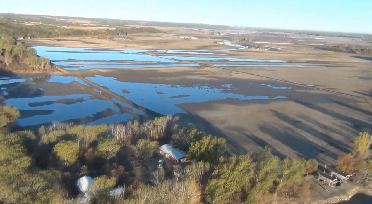
Aerial view of the floodplain south from Nathans Lake. Image from video taken October 15, 2011 by the Army Corps of Engineers, during a flight from Omaha to Decatur.

20 October 2011

Arthur County Turbine Farm Proposal

Is there an industrial wind turbine project in the future for northern Arthur county, in the western sandhills of Nebraska?

Information presented on the internet indicates Eurus Energy America Corporation, of San Diego, California, has completed a study plan document for more than 50 wind turbines.

The turbines would occur across 37,000 acres ranchland in two localities, northeast and northwest of Arthur.

The east site would extend east to west across Triangle Road, and be southwest of Swan Lake, northwest of Threemile Lake and northeast of Mechoglan Lake. They would be placed directly west of Baldy Hill, on hilltops on the north and south side of Baldy Valley.

The height of the turbines - each extending about 389 feet above the surface - and surpass 4100 feet in elevation. This would be 300 feet higher in elevation than the top of Baldy Hill, which has a hilltop elevation of 3822 feet.

The western site would be northward of Silassen Road. Turbines here would have an overall height of about 4289 feet, according to site details.

Information on project 2010-WTE-65-OE, available at the Federal Aviation Authority website, indicates a total height of 4030 feet, giving a base site elevation of 3641 feet. This was for a spot about two miles northwest of Threemile Lake.

The application was filed with the FAA in January 2010, as required for the construction of any structures which extend more than 200 feet in the air. The agency has indicated the turbines would not be a "hazard to air navigation" but will require suitable lighting to denote their location.

The Nebraska Field Office of the U.S. Fish and Wildlife Service has not received any information on this project, according to a representative. This agency is typically involved with wind turbine project due to any potential for the "taking" of birds or bats and which is regulated through the Migratory Bird Treaty Act.

Location of turbines proposed in Arthur County. The turbines are indicated by the red dots.

Landscape features and identified wetlands in the immediate vicinity of the eastern project site for wind turbines proposed for Arthur County. Wetlands determined by the U.S. Fish and Wildlife Service.