Showing posts with label habitat enhancement. Show all posts

19 March 2013

Created Spaces Are Places for Omaha Birders to Visit

Habitat work associated with the CSO! project in the Saddle Creek basin along Center Street, will establish a changed habitat and create a different space for local birdlife or other things of nature.

There will be an increased floral diversity along the creekway on the east side of Westlawn-Hillcrest Memorial Cemetery once the many types of plants are established along a defined corridor. Any animal life associated with this spot, along with the creek channel mitigation site to the westward, has to be monitored, according to the Section 404 permit acquired by the City of Omaha. This includes an indication to denote bird activities, occurrence of nests, or findings of feathers, or even visual observations that might be captured by a quick click of a camera.

Any efforts by members of the community could be helpful in achieving this goal. The question is what incentive is there for the bird-watching public to visit CSO! project green-spaces to do a bird survey and report their findings? And also have enough interest to share their findings with city officials?

For example, further details on birds, and even other wildlife could be helpful in indicating that the rigorous environmental review and need for mitigation has resulted in something beneficial. Several prominent CSO sites are within the confines of eastern Omaha, and with each of them are readily accessible, so it would be so easy to take a quick look on a day of fine weather.

Birders, during an outing of discovery, might convey that created habitat diversity and green-space are an asset to the city environs? There might be an appreciated view of some expressive bird of some subtlety? Or, with the new additions to the floral landscape, some unexpected, vivid moment might occur.

Or to convey a phrase: "You don't know if you don't go."

These surveys can also be done prior to any habitat modifications, and allow a before/after comparison. This sort of information is already available for Adams Park, Fontenelle Park and Spring Lake Park in eastern Omaha.

It would be helpful if a representative of the CSO! project would give a presentation to a local conservation group, perhaps at Fontenelle Forest or at a usual monthly meeting of the Audubon Society of Omaha. The speaker could tell the attendants about current and proposed projects, changing habitats, and that any effort to assist in some manner could be a contribution to the community!

06 March 2013

Wetland Habitat Created With Levee Reconstruction

When the Army Corps of Engineers was rebuilding levees along the Missouri River, they also did the work in a manner to create additional riverine habitat.


All images courtesy of the Army Corps of Engineers.

The two particular efforts were levee setback and excavating and grading borrow pits in a manner to allow wetlands to be established, said David J. Crane, an environmental resources specialist with the Corps.

This work was especially done at two sites in Iowa, Crane said.

Copeland Bend Mitigation Site (river miles 560-565), adjacent to Highway 2, across from Nebraska City, Nebraska.
Work here included approximately 3.6 miles of levee setback north of the highway and approximately one mile of levee setback south of the highway. This setback occurs along the Copeland Bend of the Missouri River, between river miles 565-560. About 760 acres of floodplain were opened at this site, nearly "doubling the total riverward habitat area at this location to 1,456 acres."
About 200 acres of wetland habitat were created, planted with a native mix of wetland plant species that favor the generally sandy soils in the area.
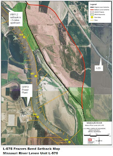
Frazers Bend (river miles 556-559); on the Iowa side of the river, about three miles south of the Highway 2 site.
This setback is approximately three miles long. About 1100 acres of floodplain were opened, "bringing the new total riverward habitat area at this location to 2,098 acres."
About 100 acres of wetland habitat were created, and will also be planted to a native mix of plant species.

The levees were being rebuilt due to damages associated with the flood of 2011.

The Iowa Department of Natural Resources (IDNR) and Natural Resources Conservation Service (NRCS), along with the local levee sponsors, Fremont County staff, and Iowa Department of Transportation were the main partners in completing this levee rehabilitation project along with the Corps of Engineers, Crane said.

"Both agencies were coordinated with frequently throughout the planning and construction phase regarding: native seed mixes, wetland construction, setback levee alignment, location of borrow sites, road relocation," he said.

The Corps has recognized several ecosystem benefits that will occur because of these projects:

  • "Increased floodplain and riparian habitat for fish and other wildlife
  • "Provides needed spawning and nursery areas for many fish species during times of high water
  • "Fish and other aquatic life entering the floodplain during high water provides food for foraging birds
    and mammals
  • "Floodwater movement across the floodplain produces plankton and aquatic insects
  • "Increased groundwater recharge
  • "More floodplain is open to receive nutrients deposited from flood waters
  • "Sediment deposition and scouring creates diverse habitat and topography on the floodplain"

The Iowa Department of Natural Resources is in charge of managing these two public areas.

Coordination with the IDNR and NRCS will continue through monitoring of the wetlands created at the setback sites.

The Copeland Bend Site along Highway 2, in Iowa.


These projects are expected to be completed during March. A Corps' article provides further information on the levee setback project.

29 April 2012

Ground Cover Netting Traps Chipping Sparrow

Plastic netting placed to hold bare soil in place, trapped and nearly led to the demise of a Chipping Sparrow.

A pair of these sparrows were observed was foraging along Happy Hollow Creek about noon, and about two hours later came word than one had been freed from the netting covering the ground.

A community volunteer planting berry trees nearby happened to notice the bird's predicament, and was able to set it free. Its head was caught in a couple of the small squares of the netting. Apparently when going after a bit of an edible, the head was stuck through the net, but when trying to pull it back out, the feathers caught and prevented any escape.

The bird could have easily died due to being trapped for a long term, or it might have fallen prey to a foraging crow, one which was noted at the site, later.

This netting covers three areas along Happy Hollow Creek where a City of Omaha project was recently done to stabilize the banks with gabion baskets full of rock. The mesh was supposed to be biodegradable, but it is not clear if that is actually the case?

The plastic material is now an obvious hazard to the many birds present in the area.

19 September 2007

Habitat Projects Along Central Missouri River to Benefit Terns and Plovers

Least Terns nesting on the Missouri National Recreational River.

By James Ed. Ducey

Work was initiated in August on habitat projects to benefit two federally listed bird species, the endangered interior Least Tern and threatened Piping Plover. This work will occur within the 59 mile long segment of the Missouri River designated as the Missouri National Recreational River. The projects are being carried out by the Army Corps of Engineers.

Contractors began work to create three emergent sandbar habitat complexes. One of the complexes will be constructed using hydraulic dredges and the other two will be constructed using mechanical earth moving equipment such as bull dozers, excavators, and scrapers, according to Luke Wallace, a biologist in the Corps' Omaha District, and project manager for the three emergent sandbar habitat projects below Gavins Point Dam..

"The sand used to construct the sandbars will be taken from the adjacent river bed at each location," according to a Corps press release. "Construction will last through fall and winter months with a scheduled completion date of April 15, 2008. Timely completion will ensure the habitat will be in place when terns and plovers return to nest next spring."

"These complexes will be constructed to provide nesting habitat for the least tern and piping plover, two bird species protected under the Endangered Species Act," according to Omaha District Commander Col. David C. Press.

Yearly populations of Terns and Plovers on the Missouri National Recreational River (Data courtesy of the Army Corps of Engineers).

Year

Least Tern

Piping Plover

1998

144

49

1999

161

141

2000

206

186

2001

232

218

2002

314

260

2003

366

286

2004

359

262

2005

476

340

2006

383

309

2007

410

300

"One ESH complex will be constructed at Missouri River Mile 791.5, near Wynot, Neb.," according to the press release. "The other two complexes will be constructed south of Vermillion, S.D., near the Highway 19 Bridge. One of those will be constructed near Missouri River Mile 774, about two miles downstream of the bridge. The other will be constructed at Missouri River mile 777.5, about 1.5 miles upstream of the bridge and adjacent to the Frost Wilderness Game Production Area in South Dakota.

The sandbars created will vary in size, according to Corps officials.

River Mile 791.5 complex = 40 acres of emergent sandbar
RM 777.7 complex = 74 acres of emergent sandbar and 15 acres of backwater.
RM 774 complex = 49 acres of emergent sandbar

The acreages of ESH listed above represent the amount of sandbar habitat that would be exposed above the water surface at a Gavins Point Dam discharge of 25,000 cubic feet per second.

The total cost of all three projects combined is approximately $8.8 million, The Corps said.

Once the project are completed next year, the response of the terns and plovers will be closely watched.

"The sandbars will be monitored weekly during the nesting season," according to Wallace. "Survey crews will locate nests and monitor the nests until the nests are terminated at which time a nest fate will be applied. Crews will monitor the chicks until they fledge. An adult census will be conducted during the nesting season. Vegetation will be monitored to determine species type and growth.

At river mile 777.5, some aquatic habitat will be constructed in conjunction with the sandbar project.

"Sediment from a historic river channel on the Frost property will be used as an alternative borrow source for the complex, resulting in the restoration of a 15-acre backwater connected to the Missouri River," according to the Corps press release. "The backwater will provide habitat for waterfowl, shorebirds, fish and mussels, and will provide new public fishing and hunting opportunities at the Frost Wilderness Game Production Area."

There has been a positive response of the terns and plovers to newly created sandbars that were the result of previous projects by the Corps.

Tern and plover use at previous sandbar habitat creation projects (Data courtesy of the Army Corps of Engineers).

Year

Tern Adults

Tern Fledglings

Plover Adults

Plover Fledglings

River Mile 755 Complex (Ponca)

2004

84

64

18

23

2005

68

12

32

6

2006

38

8

8

5

2007

68

5

11

0

RM 761

2005

58

67

42

56

2006

40

29

55

55

2007

48

20

57

20

RM 770 Complex

2005

80

102

62

76

2006

176

47

69

30

2007

94

10

73

10

"The first year of use for each of the created sandbars was very productive for both species," Wallace said. "Since then productivity has decreased though the sandbars still attract large numbers of adults. Generally the nest success has been very good at all three sites with 60-70% of the nests having at least one egg hatch. The poor productivity is probably due to predation by owls, hawks, minks, raccoons.

Newly created sandbar habitat at the Ponca Complex, 2004. Photos courtesy of the Corps of Engineers.

"The sandbar habitat has also been used by waterfowl and shorebirds and unfortunately the aforementioned raptors," Wallace said.

For safety purposes, public access to construction and staging areas will be restricted, eliminating recreation and hunting opportunities during the construction period, Sept. 1, 2007 through April 15, 2008.

These projects are part of the Corps effort to implement recommendations of the U.S. Fish and Wildlife Service in its Biological Opinion on the Operation of the Missouri River Main Stem System.

01 August 2007

Missouri River Mitigation Projects Provide New Wildbirds Habitat

Mitigation wetland along the Missouri River. All pictures courtesy of the Army Corps of Engineers.

By James Ed. Ducey

Ongoing habitat projects being carried out in conjunction with the Missouri River Mitigation Project are providing new habitat for a variety of wild birds.

"The primary focus of the mitigation project is to establish slower flowing and shallower water along the Missouri river," said Michael Sandine, natural resources manager for the Missouri River mitigation project, in the Omaha district of the Army Corps of Engineers. "The goal is to provide a corridor of habitat for various native species, including amphibians, birds, fish and mammals."

The habitat development practices being implemented at numerous mitigation sites include:

* "Create native and diverse habitats
* Preserve and improve riverine habitats and processes
* Preserve and restore wetland habitats
* Preserve and restore upland terrestrial habitats
* Create opportunities to reconnect the floodplain to the river
* Create areas that will require mostly passive management," according to the 2006 annual report for the project.

There were 46,555 acres of mitigation lands acquired as of September 30, 2006. A variety of habitat types have resulted, with a return to native type vegetation the most extensive, followed by grassland and forest.

Water conditions at Saint Marys Island mitigation project site.

Project lands are purchased only from willing sellers.

New shorebird habitat created at Copeland Bend in 2006 has been used by shorebirds.

"Two depressional wetlands were built on the protected side of the river levee which seem to be attractive to shorebirds and serve as a water hole for other species," Sandine said.

This bend project was developed by the Corps, and is now managed by the Iowa Department of Natural Resources.

Bank Swallows have established a breeding colony at Kansas Bend, near Peru, Nebraska.

After two new water chutes were established in 2006, the effects of erosional activity of the river water in one chute created earthen banks 12-14 feet in height, Sandine said. The swallows dug nesting burrows this season.

Additional chute creation work occurred at Schilling WMA northeast of Plattsmouth last season, and is currently undergoing the erosional affects of the river flows.

Examples of sites where work has been underway this season include: excavations of backwater areas at Hole in the Rock, finishing excavation of a mile-long chute at Council Bend on the Iowa side of the river northwest of Council Bluffs, and wetland construction at Langdon Bend, Nebraska.

Digging a mitigation wetland.

Dig work at mitigation wetland.

A particular emphasis this current fiscal year is to acquire strips of land along the river channel, to allow the completion of "structural modifications to the existing bank protection and navigation dikes. The changes will encourage the river to widen and create more shallow water habitat in the dike fields," the annual report said.

Map of restoration project at Langdon Bend, Missouri River. Courtesy of ACE.

Sandine enjoys seeing the changes in habitat as mitigation sites evolve from their former land use. "It is interesting and gratifying to see smaller species on the successional ground, such as the profusion of native sunflowers that are used as a seed source for small wild birds."

"The Missouri River Mitigation Project (Project) is designed to mitigate, or compensate, for fish and wildlife habitat losses that resulted from past channelization efforts on the Missouri River. The Project extends from Sioux City, Iowa to the mouth of the Missouri River near St. Louis, a length of 735 river miles," according to the project website.

Congress authorized construction of the mitigation project in 1986.

Implementation of the project started in 1991, with the first project the re-opening of a riverine chute near Marshall, Missouri at the Grand Pass Conservation Area.

There was $132,792,000 of federal funds expended on mitigation efforts in the Corps' Kansas City and Omaha districts, from fiscal year 1992 through fiscal year 2006, according to the projects' December 2006 Annual Implementation Report. An additional $23 million was provided for the 2007 fiscal year. Cost of the overall, authorized project is expected to exceed $1 billion with additional activities in the next few years.

The Corps typically licenses mitigation sites to state agencies which then manage the tracts for uses such as bird watching, fishing, hunting, and other outdoor recreation. The Omaha Nation manages the Hole in the Rock site.


This alternative version of the map has a link to the site webpage, if available.
Missouri River Mitigation Project Website

18 June 2007

After 70 Years, Piping Plover Breeds Again at Crescent Lake NWR

Two Piping Plover fledglings and adults from Clear Lake, June 17, 1902 as collected by J.E. Wallace. Clear Lake is now part of Valentine NWR. Specimens at the University of Nebraska State Museum.

By James Ed. Ducey

The Piping Plover is nesting again - after a 70 year hiatus - at Crescent Lake National Wildlife Refuge.

"A pair of plovers are nesting on an island in Goose Lake," said Neil Powers, manager of the refuge in the western Sandhills. "Early reports stated that there were two nests and numerous adults. However, our wildlife biologist has confirmed one nest with four eggs, and two adult" Piping Plover on Friday, June 15.

Six plovers and two active nests were reported for June 9th on the refuge, by a visiting birder.

The record of breeding is the first for the refuge since a small group of Piping Plover, including young, were noted during mid-June 1937.

Islands where the plover are nesting were "reconstructed beginning in the fall of 2005 and were completed last year." Powers said. "In addition to the plovers, over 50 avocet pairs are also calling the islands home."

The islands were reconstructed using a low-ground-pressure bulldozer which simply pushed material from the lake bottom into an island already present,” he explained. “The two islands comprise about 2.5 acres, and are designed to provide secure nesting and loafing sites for migratory birds.”

"Frequently, our management efforts are a conglomeration of partnerships involving the assistance of neighboring cattle producers and other entities," added Powers. "It's very rewarding to see all steps in the planning process come together to complete a project and even more so when these management activities attract species of special concern."

In 1993-94, these plover were noted at Bean Lake, adjacent to the west side of the refuge. A pair was present, with no specific documentation of breeding, though birds were present during the proper time.

A number of Piping Plover are typically resident at Lake McConaughy each season, with a small chick seen June 3, by a Nebraska birder.

The species is a regular migrant in the sandhills region, with a few birds occasionally noted especially at lakes with barren, sandy shores. The belted subspecies is usually observed.

The Piping Plover is classified as a threatened species by wildlife agencies.

Great Plains Piping Plover.